The derring-do Mars helicopter is about to take on its greatest challenge yet.
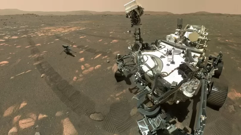
The Ingenuity drone, which accompanies Nasa’s Perseverance rover, is going to start flying over the hills that surround their exploration location on the Red Planet.
The pair are currently on the floor of Jezero Crater, but the plan is for them both to climb up and out of this bowl.
Ginny, as the drone is known, has therefore had to have software upgrades to allow it to navigate inclines.
« Up until this point, Ingenuity has always lived in the belief that Mars is completely flat, like a pancake, » chief pilot Håvard Grip told BBC News.
« It’s only now with these most recent software updates that we are able to tell Ingenuity that ‘no, in fact, it’s not flat; there are hills’. »
Ginny made history in 2021 by becoming the first vehicle to achieve powered flight on another world.
It was a straight-up-and-down manoeuvre to an altitude of only 3m, but it proved the principle.
Since then, the chopper has flown higher and further on 35 more occasions.
Not bad for what was supposed to be just a short technology demonstration. But the opportunities a scout helicopter affords were simply too good for Nasa to pass up.
The drone now supports Perseverance by examining the road ahead, helping the wheeled robot and its « backseat drivers » on Earth pick the right path.
It’s also doing science, taking airborne pictures of rock outcrops from multiple angles so researchers can build 3D models of interesting targets for further investigation.
But the future is about to get a lot harder. As soon as Perseverance has dropped some rock samples on the ground for later collection and return to Earth by missions at the end of the decade, the rover will head for high ground. And Ingenuity will tag along.
The pair will climb the 40m-high deposits of an ancient river delta feature, and then make towards the rim of Jezero Crater.
The newly installed software will allow the chopper to make the necessary navigation corrections when the ground in front of it rises.
It should also help with another issue: hazardous rocks on the ground at the moment of landing.
Engineers back on Earth currently analyse satellite imagery to find safe sites to touch down. « But it’s harder to correlate orbital imagery to small rocks on the ground in the hills. That’s where this other feature comes in, where, right before landing, Ingenuity itself can take a look at the ground and figure out where the rocks are and avoid them, » explained Grip.
The chief pilot keeps a log book in which to record all Ginny’s flights. It’s now full.
« We were only ever going to fly five times. We thought, well, a book with only five pages is just gonna look too silly. And so we put a bunch of extra pages in there just so it would look more like a real book. But guess what? We are out of pages. Ingenuity has made its 36th flight, and, coincidentally, that flight also marked the threshold for Ingenuity having spent a full hour in skies of Mars. »
Håvard Grip was reflecting on Ingenuity’s success at the American Geophysical Union Fall Meeting in Chicago.


Leave a Comment
You must be logged in to post a comment.